What is Lidar Data?
Lidar (light detection and ranging) is an optical remote-sensing technique that uses laser light to densely sample the surface of the earth, producing highly accurate x,y,z measurements.Lidar is an active optical sensor that transmits laser beams toward a target while moving through specific survey routes. Lidar can see through objects, such as walls or trees.
Two types of lidar are topographic and bathymetric. Topographic lidar typically uses a near-infrared laser to map the land, while bathymetric lidar uses water-penetrating green light to also measure seafloor and riverbed elevations.
Today Lidar is being used for computer vision to discover lost cities, train autonomous vehicles, track climate change, and much more.
One of the most common uses for Lidar is tracking the speed of vehicles. Lidar is useful because it is accurate, fast, and can be used in any location where the structure and shape of the earth’s surface must be determined.
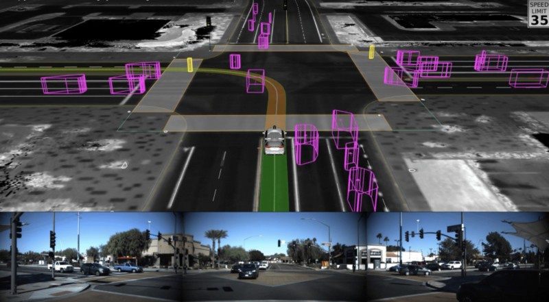
Lidar Data Annotation
Lidar Annotation is performed to train self-driving cars. Lidar annotation is very similar to image labeling in its essence but different in practice for a simple reason: the point cloud is a 3D representation on a flat screen. In addition, humans have to deal with a huge amount of points (in the order of millions) which are not contained by well represented and defined surfaces or boundaries. So, even for the human brain, it’s not trivial to understand which point belongs to which object, and if you zoom into the point cloud image, this difficulty becomes clear. Lidar data annotation is usually performed using the same structures of classes that guide the image labeling practices, such as bounding boxes.
Annotating Lidar point cloud data is challenging due to the following issues:
1) A Lidar point cloud is usually sparse and has low resolution, making it difficult for human annotators to recognize objects
2) Compared to annotation on 2D images, the operation of drawing 3D bounding boxes or even point-wise labels on Lidar point clouds is more complex and time-consuming.
3) Lidar data are usually collected in sequences, so consecutive frames are highly correlated, leading to repeated annotations.
Bounding Box Annotation
Drawing 3-D bounding boxes to annotate and/or measure many points on an external surface of an object. These typically are generated using 3-D laser scanners, Radar sensors, and Lidar sensors.These are used to detect and monitor objects with greater precision, including single points, to gather information such as scale, position, speed, yaw, pitch, and class.
Semantic Segmentation
Lidar point cloud segmentation is a technique for classifying an object with additional attributes that can be detected by any perception model for learning. 3D point cloud annotation services help self-driving cars differentiate between various types of lanes in a 3D point cloud map so that they can annotate the roads for safer driving with more accurate visibility using 3D orientation.
The task of manually segmenting every single point in the scene is massive and requires a lot of attention to detail. Semantic segmented data provides autonomous vehicles with a deeper and finer interpretation of their surroundings.
Wrapping Up
Lidar data must be appropriately labelled to be helpful for computer vision, and more especially, supervised machine learning, which is a massive operation that can be difficult to scale. The difficulty for AI engineers is converting enormous amounts of unstructured data into structured data that can be utilised to train machine learning models. That requires hours and hours of labeling data to prepare it for training machines to interpret and understand the visual world.
This calls for an annotation partner who understands managing the “rhythm” of such a complex workflow. We at TagX have been involved in multiple projects where we have reduced the handling time of such micro tasks by orders of magnitude!
At TagX, we understand that annotating data for computer vision models requires a strategic combination of people, process, and technology. In fact, it’s our specialty. If your organization works with Lidar technology, our professionally managed teams of data analysts can help.

No comments yet