Property surveying is the initial and crucial process for architects as it provides essential data and information about a site, which forms the foundation for designing and planning any construction project. Property Survey Service London involves measuring, mapping, and documenting various aspects of the property or land, including its boundaries, topography, existing structures, utilities, and other relevant features. This post will explain the critical steps involved in property surveying for architects.
Project Brief and Objectives: The first step in conducting a property survey is to understand the architect's project brief and objectives. This involves discussing with the client or architect the deliverables to determine the time frame and cost of the survey, the extent of land to be included and surveyed or only main property, and any specific requirements or challenges associated with the site.
Research and Documentation: Before setting foot on the site, we perform research and gather information related to the property. Look at the street view on Maps, Google earth, any existing plans from any listings or old plans and photos. Understanding the scope and description for the work is essential to ensure accuracy and provide correct estimated cost and time frame.
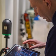
Fieldwork: Fieldwork is a fundamental aspect of property surveying. Surveyors use specialized equipment, 3D scanner to collect precise measurements and data points on the site. They establish control points and benchmarks to reference measurements and ensure accuracy throughout the process.
Boundary Survey: One of the architects' primary tasks is establishing the property's boundaries. This involves measuring and mapping the property boundary and we display this information in our Block plans or Topography (Where clearly visible).
Topographic Survey: A topographic survey focuses on mapping the physical features of the land, such as elevation changes, natural and artificial landmarks, trees, water bodies, and utilities. This data is crucial for architects to understand the site's contour, drainage patterns, and potential design constraints.
When Utility Survey are also required as part of the process, these are done by other companies and we can help to connect with the right experts: Identifying the location of existing utilities (e.g., water lines, sewer lines, gas lines, electrical conduits) is vital for architects to design around or avoid potential conflicts. Surveyors collaborate with utility companies and use specialized equipment to mark underground utilities' positions accurately.
And the same with Environmental Assessment this is an essential part of the survey and we don't do this service in house but have connections with companies who can help you: An environmental assessment may be required depending on the project's scale and nature. This involves identifying any environmental factors that could impact the construction process, such as protected species, wetlands, or potential contamination.
Data Analysis and Processing: Surveyors process the collected data using specialized software after completing the fieldwork. They create detailed maps, 3D models, and other visual representations of the site, which are valuable references for architects during the design phase.
Collaboration with Architects: Once the property survey is complete, surveyors collaborate closely with architects to ensure that they understand the site's features and limitations. The survey data informs critical design decisions, such as building placement, orientation, and potential modifications to accommodate existing features.
Property Survey Service London is an indispensable process for architects, as it provides them with crucial data and insights about the site they are working on. From establishing boundaries and mapping topography to identifying utilities and potential environmental considerations, the information gathered during the survey lays the groundwork for successful and informed architectural design and planning. By leveraging modern surveying technologies and methodologies, architects and surveyors can collaborate effectively to create innovative, safe, and sustainable built environments.
Resource: https://spacesurveyuk.wordpress.com/2023/08/05/steps-involved-in-property-survey-service-london/

No comments yet